Region Dunkelsteinerwald
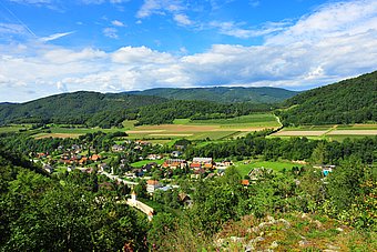
The Dunkelsteinerwald region is geographically situated in the triangle between St. Pölten, Krems and Melk. The region’s north-west border is formed by the Wachau and the Danube valley. To the east and south, the region rolls away gently into the foothills of the Alps.
In geological terms, the Dunkelsteinerwald is the south-eastern section of the Bohemian Massif, which was cut off from the Waldviertel by the Danube. The region covers a total of 177.4 km² and has 8,740 inhabitants (as at 1.1.2014) living in the six municipalities of Bergern im Dunkelsteinerwald, Schönbühel-Aggsbach, Dunkelsteinerwald, Haunoldstein, Hafnerbach and Neidling.
Its location in the above-mentioned triangle gives the region significant economic and functional advantages. Of particular note is the direct access afforded by the Westautobahn via the Loosdorf interchange from the south and the Melk interchange from the West.
On the other hand, the location between three urban agglomerations and in three different political districts also presents the region with disadvantages, some of which are painfully felt in a lack of regional identity and in outflows of purchasing power, economic strength and labour, and are the reasons for the close cooperation between the six municipalities.
In 2011, the municipalities of the Dunkelsteinerwald overhauled the small regional development concept of the Dunkelsteinerwald region and redefined their development priorities for the coming years.


